![]()
Feature Image: Planet Labs Inc.
Satellite data and imagery is more available and accessible than ever thanks to a continuing shift in data policies. Through platforms like Google Earth Engine, satellite images are available not only to researchers and scientists, but to interested members of the public, journalists and media outlets.
Throughout the pandemic, journalists used satellite imagery to show how the Earth changed when physical human movement was restricted. For example, satellite imagery providers such as Planet has shared images of carless streets and Venice’s empty canals (seen in our feature image), flooding news reports and our social feed .
We also saw space agencies share news showing how pollution levels over Europe decreased during the pandemic, as seen in the European Space Agency example below.
But as satellite images are used more frequently in mainstream media, we should be asking the questions:
- Where have these images come from?
- What are these images being used for?
- How were these images created?
With more people having access to satellite data, images could be misused to push personal agendas or because the person sharing the image doesn’t realise it is a fabrication. Below are a couple of ways satellite imagery can be misused.
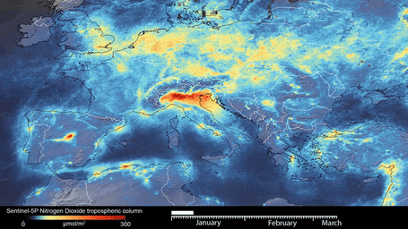
Image: European Space Agency
MISREPRESENTATION OF FACTS
When it comes to misrepresentation, the satellite image and data is real but its purpose has been misconstrued to convince people of something that isn’t happening. This could happen either by accident, or worse, deliberately.
It is as easy as tweeting a real satellite image from a reputable source (like NASA) and referencing it with false or misleading information. This combination of activities is more likely to lead people into believing a fake story.
On the flipside, someone with no satellite expertise may have simply misinterpreted the data. This happened in 2003 when a British television news report aired a satellite image of a deadly North Korean train disaster, when the image was actually of a fire in Iraq taken a year earlier.
FAKED SATELLITE IMAGES
These are simply made up images or real images that have been altered to show something that wasn’t in the data. As an example, this image of Earth from space shows a spectacular view of Europe sparkling with lights. But if you look close enough….
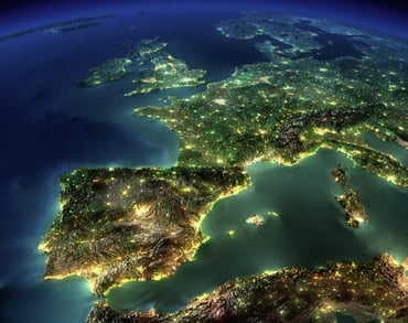
Image: Anton Balazh
It is fake.
The image is actually a computer rendering created by Russian graphic artist, Anton Balazh. Yet, it was shared around the internet as a legitimate NASA photograph because for the untrained eye, it looked real. So, how can people learn access and search for satellite data to fact-check?
HOW CAN I AVOID USING OR SHARING A MISLEADING OR FALSE SATELLITE IMAGE?
Many of us are guilty of pressing the share button without thinking too much about it, and by doing so may be contributing to the spread of false information. This is an innocent mistake we may not even realise we’ve made.
However, when you are sharing anything online in an official capacity (especially on behalf of your employer), it is imperative you are doing your best to share true and accurate information.
To avoid spreading a misleading or false satellite image, or responding to something that hasn’t actually happened, consider taking the following steps:
- Go straight to the source: Are they a credible media provider or a sketchy twitter account? This can give you a feel for the validity of the image and the claims it is making.
- Verify the image and context: If the image is claiming to come from a reputable provider such as NASA, contact them to ask if they have published a similar image and in what context. If they have the image on their website, you can verify it yourself.
- Ask a professional: If you’re unsure of the claims made about what is happening in the satellite image, ask an expert. A platform like Twitter harbours passionate professionals happy to give you their educated opinion.
- Check location and time: Images not showing date or location are a red flag because this makes them difficult to verify.
DO YOU NEED TO TELL A STORY USING EARTH OBSERVATIONS?
EO Data Science is a specialist in the deployment of Google Earth Engine and can help you understand, procure and implement satellite imagery data to unlock the potential for visually compelling stories and more.
Back To News Stories